

Usually when on a long distance walk I avoid using any form of public transport. However, given the state of my knees, I hopped on a bus yesterday evening to travel the three miles into the centre of Oxford for a pint and bite to eat. It was a pleasant bus journey there and back and took no time at all. My original plan for this morning was to walk from my overnight accommodation in Headington, but whilst travelling the route on the bus yesterday I observed there was nothing to be lost if I started walking from the centre of the city.
The buses are so frequent that I only wait a minute before boarding, the friendly driver reminds me that my Senior bus pass is not accepted at this early hour of the day so I pay my dues and take a seat with the commuters and school children. I rarely travel by bus but when I do I always enjoy hearing the snippets of conversation, today it is two teenage school girls talking about the merits of potential boyfriends.
Disembarking in the High Street I stop to put on my full set off waterproofs and then head off along the road towards the city centre.
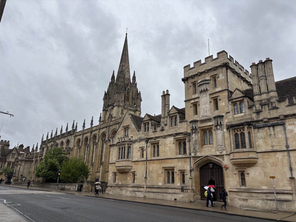
Turning left into St Aldgate’s I pass Tom Tower. This was designed by Christopher Wren and was built in 1681-82 and sits above the main entrance to Christ Church which was founded by Henry VIII in 1546. The tower houses “Great Tom” said to be the loudest bell in Oxford and it weighs an impressive six and a quarter tons.
Continuing down the road I cross Folly Bridge and get today’s first glimpse of the River Thames. It will be a familiar sight for much of the day because I will be following the Thames Path to Sutton Bridge which is south of Abingdon and then heading across country to Wantage.
Just after crossing the bridge I take a path on the left way-marked as the Thames Path. My knees are particularly painful when going up or downhill so I am looking forward to a few hours of walking on flat ground.
Within ten minutes I am passing the Oxford University boathouses, each College has their own boathouse with mos located along this stretch of the Thames. According to the Visit Thames website the stretch of river between Osney Lock and Iffley Lock is known by its Roman name the Isis.
The rain is now hammering down and looks to be set in for most of the morning so apart from the occasional dog walker or jogger I have the towpath to myself.
As I approach Iffley Lock I pass a small stone bridge commemorating the opening of the lock in 1924 by Lord Desborough, the then chair of the Thames Conservancy.
Iffley Lock was originally built in 1632 and then rebuilt in 1793 and further improved and enlarged in 1802 and 1806. The lock keepers cottage was built in 1810.
I now have the feeling of being out in open countryside and all of a sudden the rain stops so I can remove my waterproof gear. The tranquility is disrupted by passing under the busy A423. I haven’t seen anyone else for a while and despite being close to the suburbs of Oxford it is very peaceful.
As I head towards a railway bridge the view is dominated by overhead power lines.
After going under the railway bridge I reach a meadow with moorings on the far side of the river. Unfortunately the power lines still dominate the view away from the river.
A bit further down the river on the far side is the “voco” hotel at Sandford-on-Thames which was acquired in 2019 by the Intercontinental Hotel Group. Apparently the building has a history dating back to the Middle Ages and in 1240 Thomas de Sandford donated the property to the Knights Templar and it served as their regional headquarters.
At Sandford Lock it is time for a break and a cup of tea. Whilst resting I read on my phone that Jerome K Jerome described this as “a very good place to drown yourself in” in his book Three Men in a Boat. It is thought he might have been referring to the weir, known as the “Big Lasher” which has been the site of a number of tragic accidents.
The lock itself was first built in 1630 and rebuilt in 1795 and 1836. It is the deepest non tidal lock on the Thames.
Setting off again the route is increasingly taking on a rural feel.
Then around the corner I reach Radley College Boathouse which sits on a lovely spot on the river.
A little further down, on the opposite side of the river is Nuneham House boathouse. Nuneham House was built in 1756 as an eighteenth century villa in Palladian style. It was owned by a number of wealthy families until the Harcourt family sold it to Oxford University in 1948.
The path soon takes me through what appears to be someones river front garden and then after passing under another railway bridge I go through a wooded area and the way markers eventually lead me to Abingdon Weir.
Crossing the weir I read on an information board a brief history of the Upper Thames Patrol, it was set up in 1939 to patrol and protect the Thames between Lechlade and Teddington. The fear was that the river might be used for an invasion or the locks be subject to sabotage or attack. It recruited 6,000 volunteers to regularly patrol the river in boats and along the banks in vehicles.
The path takes me across the lock, this lock was built in 1790 however there are still remains of the original 1624 lock, making this the oldest lock chamber in the UK. The lock house was built in 1928 by the Thames Conservancy.
Just after leaving the lock there is a convenient bench for a refreshment stop whilst enjoying the view of the weir.
Heading off again I now have the river on my right and I am close to the centre of Abingdon. My original plan had been to have a brief wander around to see if I could locate the house my great grandfather lived in during the mid 1860’s . I know it was close to the river crossing, however my knees are extremely painful and I don’t want to add more distance to today’s walk.
After going under Abingdon Bridge I get a fine view of the spire of St Helen’s Church which sits close to the river.
Soon the view across the river is of The Old Anchor Inn, built in the mid 17th century it sits on St Helen’s Wharf. A pub by the same name was originally located closer to the river, but in 1884 the landowners, Christ’s Hospital, decided to widen the roadway and the pub was demolished, however the name was kept when the present premises were granted a license on 30th August 1884.
The Thames Path path now goes through meadows as it head towards Culham Bridge and then crosses a wooden bridge. In his book ‘Vagabonds and Puppets’ published in 1930, the philosopher and puppeteer Walter Wilkinson described performing a puppet show on a grassy area at Culham Bridge. I assume it would have been close to this spot.
I now continue on towards Culham Lock, the final section leaves the Thames and goes along Culham Cut. This was excavated in 1809 to create a safer passage along the Thames and a new lock was built at Culham.
The lock keepers house at Culham lock was built in 1809. A bit further on is a small green area. This is close to Sutton Bridge which is a lot closer to Culham village than Culham Bridge. So it would have been more logical for Walter Wilkinson to have performed his show here. As I have found on other walks his description of where he performed does not always appear wholly accurate.
I now cross the bridges, there are two close together here, and then take a footpath on the right which heads across a field towards Sutton Courtenay. The path takes me into the village opposite The Fish public house where I cross the road and continue on a footpath to the left of the pub.
The path goes along a lane at the back of properties and then at a junction of paths I turn right and wander down to the interesting looking All Saints Church parts of which are Norman. Equally interesting is the graveyard which is the last resting place of the former Prime Minister, Herbert Askwith, the novelist George Orwell, and David Astor the former owner of the Observer Newspaper and son of Waldorf and Nancy Astor, she was born in America and became the first seated women Member of Parliament
From the churchyard I follow paths through to the High Street and then turn left to walk through the pleasant village which has some attractive old cottages. It is hard to believe that on the edge of the village is the site of the Didcot Power Station, a landmark besides the A34 until it’s towers were demolished between 2014 and 2020.
I pass the site of the former Plough pub, newspaper reports say this was closed in 2016 and an application for change of use and development was made by the company that had purchased it in 2024. Despite a campaign by locals the application was granted. It is such a pity when a community loses a pub.
Just after passing a petrol station I turn right into Milton Road and keep on this road until I pass the last house on the left, here I take a footpath on the left. This is the route of The Vale Way, this is a 27-mile long route from Abingdon to Longcot. After 500 metres at a junction of paths I turn right and stay with the Vale Way as it heads towards Milton.
Reaching the village I join School Lane and pass the Squire Barrett Recreation Ground, apparently the Barretts purchased Milton Manor House and estate in 1764 and successive generations lived in the manor and ran the estate.
On reaching the High Street I head diagonally across and join a lane which passes the unusually named Plum Pudding pub. Apparently this pub was originally called the Red Lion and then for decades was known as the Admiral Benbow. In 2013 the current landlords purchased the pub and changed the name to Plum Pudding, apparently in recognition of the Oxford Sandy and Black pig which was nicknamed the “Plum Pudding Pig” and is one of the country’s oldest heritage breeds dating back nearly 300 years, it was commonly found in Oxfordshire.
Soon after the pub I take a path on the right running alongside the village church before joining a lane to pass Milton Manor and then go through an area of woodland by a stream to reach a bridge across the busy A34.
On the far side of the main road I continue along the track, Milton Lane, heading towards Steventon. This is an interesting lane which was obviously dissected by the construction of the A34, nearing Steventon the route becomes cobbled. Later research on the Historic England website records this section of path as a medieval cobbled raised causeway probably built by the Black Monks of Steventon. With records of repairs dating back to 1419. Just imagine the folk that have walked this route.
I continue through the village which has a number of fine old cottages.
After crossing the High Street I join The Causeway. This is another raised cobbled path.
At a junction of roads I turn left to walk in front of the North Star pub. At the moment the pub seems to be undergoing repairs. Apparently this is one of the few pubs left in the country that does not have a bar, the beer is dispensed from barrels in the the tap room. The pub gets its name from an old Brunel locomotive which travelled on the London to Bristol line.
I am now walking along Stocks Lane and soon go over a railway crossing and then as the road turns to the right I continue straight on a track heading uphill towards Steventon Copse. After passing the trees the track levels out and then just before reaching a crossing of tracks I spot the Ordnance Survey Steventon Hill trig pillar. This is the 525th trig I have bagged.
At the junction of paths I turn right and walk back towards the western side of Steventon Copse. The path descends steeply through the trees to reach a track which leads to Mill Lane which I follow until I reach a junction with Church Lane. Here I turn left and walk by St Michael’s and All Angels church which is heavily clad in scaffolding.
After passing the church I continue through fields heading towards Woods Farm, to my left is East Hendred Brook.
After passing the farm the track soon heads across arable fields.
I ignore a footpath leading off to the left and soon after reach a track where I turn left, still on the route of the Vale Way, and head south towards the A417 and West Hendred. After passing the Extraordinary Hare pub I cross the A417 and head south along The Greenway.
After 200 metres I take a footpath on the right which heads across fields towards Ardington.
On reaching the village I walk along the High Street and pass Holy Trinity church.
I am now walking along School Road and follow this as is heads out of the village passing woodland and then go straight across at a crossroads to follow the lane past a garden in the hamlet of West Lockinge established by “Parkinsons.Me” a charity supporting people living with Parkinson’s Disease.
Soon after passing the garden I take a track on the right to follow the Vale Way towards Wantage.
Reaching the outskirts of Wantage I pass allotments and then turn right into Lark Hill and follow this to reach a junction where I turn left into Charlton Road and pass the Lord Nelson pub. This busy road becomes Wallingford Street as it nears the centre of Wantage. I stay with it until it reaches the Market Square and the Bear Hotel which is my resting place for the evening. This hotel is over 500 years old and it appears to be in the process of some redevelopment. The pictures of their rooms on-line promised well furnished and recently decorated rooms. Sadly the room I am allocated does not reach this standard but one can only hope it is on the list to be refurbished!
Today I have walked over 24 miles on painful knees so after a quick pint and bite to eat I am off to bed.
To follow my walk you will need Ordnance Survey Explorer 180 Oxford; 170 – Abingdon, Wantage & Vale of White Horse
You can view this walk and download the GPX File on OS Maps (OS Maps subscription required)
8th June 2026
© Two Dogs and an Awning (2026)
All information on this site is provided free of charge and in good faith and no liability is accepted in respect of damage, loss or injury which might result from it. To the best of my knowledge the routes are entirely on public rights of way or within areas that are open for public access.
Walking can be hazardous and is done entirely at your own risk. It is your responsibility to check your route and navigate using a map and compass.