

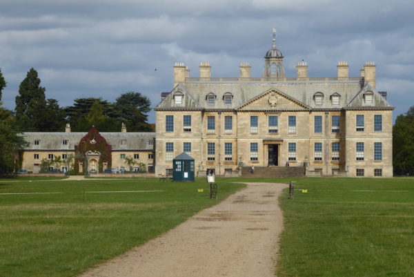
Today Lynnie is visiting Belton House a National Trust property close to Casthorpe House Farm CL, so I will be walking from the property’s visitors’ car park. Belton Park was built in 1688 by Sir John Brownlow and remained in the ownership of his relatives until 1984 when it was transferred to the National Trust. I leave Lynnie to wander around and head south along the driveway through the deer park.
Apparently this used to be the main driveway to the house, in just over a mile I reach the Lion Gates.
I turn left along Londonthorpe Lane soon passing Belton Park Golf Club and then as the road turns sharp left I turn right to enter Alma Park industrial estate and after a couple of hundred yards take a footpath on the left leading through industrial units. I am just beginning to question my choice of routes when I reach the entrance to Alma Park Woodland Trust reserve. The information board explains that South Kesteven District Council donated this downland to the Woodland Trust in 1993 and it is connected to the Trust’s Londonthorpe Wood to the north. I follow a path uphill.
Emerging on the edge of an arable field I turn left along the edge of woodland and then join a track heading to Londonthorpe. On reaching a road I turn right into the village and then take a turning on the left to wander down to the solid looking church of St John the Baptist.
On our travels we have visited many churchyards, I cannot recall any, more attractive than this one. Although I am not sure that describing a churchyard as attractive is the right term. It has wonderful views over the valley and there are rows of immaculately maintained Commonwealth War grave headstones. These mark the resting place of thirty-one soldiers who lost their lives in the First World War. There was a military hospital at Belton Park, but unfortunately these men did not recover from their injuries. It is a poignant reminder on a sunny afternoon that men from throughout the Commonwealth fought in the Great War.
I walk back to the High Road and turn left out of the village, stupidly I am not concentrating, my mind is still on those young men who travelled from the likes of New Zealand in 1914 -1918. I wonder at their thoughts at the time, I am sure they left home fully expecting to return. As a consequence I miss a footpath on the left and by the time I realise I am almost at the junction for the B6403, this is the old Roman Road on Ermine Street.
At the junction I turn left to walk besides the road, there is a wide verge but I still need to keep an eye out for the traffic which is travelling at speed. It is about quarter of a mile before I can turn right and join a quiet lane leading into Welby. Had I been more alert the footpath from Londonthorpe would have brought me to a point opposite the turning. As I enter the village I pass on old water pump.
Then on reaching Church Lane I turn right. I have deduced over the years that somewhere on Church Lane, or Church Road is a church! This one is St Bartholomew’s Church. I am tempted to wander around but do not want to leave myself short on time to get back and meet up with Lynnie.
I therefore, turn around and walk back into the village and turn left and after passing Lordship Farm take a footpath signed to a track heading north out of the village. It is a cracking afternoon now and it is good to be out in the open countryside. At a junction of tracks I turn left and follow the path by the hedgerow beside arable fields. I had hoped that on meeting the B6403, Ermine Street, I would have been able to take a track opposite, but it appears there is no public access so I turn right following the wide roadside verge.
Ermine Street was a major Roman Road running from London to Lincoln and then onto York. As you would expect this section is dead straight and even when the verge narrows there are plenty of opportunities to seek refuge from the oncoming traffic. Nevertheless I am pleased to be able to turn left off the road and take the lane besides RAF Barkston Heath.
After a mile the road sweeps to the left and after another long straight section bends to the right before heading downhill towards Belton. At a junction I turn left to walk towards Bellmount Tower, this is a busy section of road that is obviously used as a rat run from the Alma Park industrial estate. It is not a relaxing walk as the verge is narrow.
Eventually I reach the turning to Bellmount Tower, however, to my dismay I discover there is no means of entering Belton Park here. Time is short so I have to make a hasty retreat back along the road, this is turning out to be a bit of a nightmare of a walk; one I would do differently another time! Back at the junction I turn left and walk down into the very attractive village of Belton.
However, I am mindful that Belton House closes soon and it has started to rain so I choose not to linger. Lynnie won’t want to be waiting in the rain, I get back, hot and flustered from my exertions with a few minutes to spare. Lynnie tells me about her enjoyable visit to the house she found the guided tour of below stairs particularly interesting.
My walk has covered eleven miles, sections of which have been very pleasant but others have been frankly a bit scary due to the traffic. A walk I won’t be repeating!
To view this walk on OS Maps Click Here
To follow our walk you will need Ordnance Survey Outdoor Explorer Map 247 – Grantham
20th September 2017
© Two Dogs and an Awning (2017)