

My knees are still playing up, particularly the right one, so there is no chance that we will be able to climb any hills today. Lynnie is again keen to explore and do a walk that we have not done previously. So after wishing Lolly and Toby a safe journey home we look at the map and decide to head towards the Forest of Bowland.
The last time I walked in the Forest of Bowland it was a disappointing affair back in 2014. I was all set for a good stomp over some hills only to find that the area I was heading for did not allow dogs. The signs said it was something to do with wild life conservation, but the area was also covered with Grouse Butts so obviously not the conservation of Grouse.
Our destination is on the eastern edge of the Forest of Bowland close to the village of Tosside. We are heading to Stocks Reservoir, we think this should be a fairly level walk so not too challenging on my knees. Our starting point is the School Lane Car Park, by the remains of a church built in 1852.
After our walk we plan to have a look around but first it is time to get a few miles under our belts. We turn right to walk around the reservoir anti-clockwise. After walking through a section of woodland we cross a field reaching what remains of Birch Hill Farm, apparently the rest is under water in the reservoir.
After crossing over Hasgill Beck on Lock Bridge, we carry on up towards the remains of New House Farm. Here we go through a gate heading down to the footbridge over the River Hodder. The footbridge was constructed in 2006 and seems very high. Apparently the annual rainfall here is around 5 feet, explaining why the bridge needs to be so high.

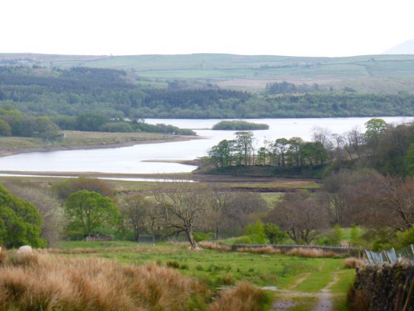
We walk uphill slightly and follow the path across fields to reach a track leading back towards the banks of the reservoir. There are cracking views from here.

We pass fishermen returning in their boats and then walk through a car park to pick up a tarmac road that leads through a remembrance garden planted with trees dedicated to lost loved ones.
Rounding the corner we walk down towards the dam. We have been across a few dams on our travels and they all have a different feel to them. This one was opened in 1932 by HRH The Prince George KG. However work on the reservoir started ten years earlier.

Significant infra-structure was put in place to develop the reservoir prior to 1922. A road between Long Preston and Tosside was constructed and a railway line from Tosside to the site of the dam, a distance of around five miles.
A village was built to house 300-400 construction workers and their families. It had its own electricity, sewerage and water supply (it would have been ironic if it did not have fresh water). There was also a canteen, cinema and recreation hall. All of this has long since gone, which seems a pity to me.

After crossing the dam we walk across open land before entering woodland to emerge by the causeway. A fine bridge that appears to be a favorite location for those not wanting to pay to use the car park. It is also home to an abundance of litter. I am not sure why folk have to spoil a spot like this by discarding their drink cans and food wrappers. I pick up a yet another can of Monster Energy drink and carry this with me back to the car park where we started our walk. Not a difficult task and I am not sure why the bastard who consumed its contents could not have been more thoughtful in the first place.
We are now back at the site of the Church, which was demolished when the reservoir was built. There was also a burial ground whose residents were moved because of fear of contaminating the water supply. A new church was built further up the road, outside of the water catchment area, using a lot of masonry and fittings from the original church.

The old village of Stocks now lies below water, by the early 1900’s it was sparsely populated. By the 1920’s it was a major construction site and by 1932 flooded to create the reservoir.
On the way back we stop to look in at the new church. However, just as we pull up we realise folk are arriving for the Sunday evening service. So we satisfy ourselves with a look at the outside and head back to Brigholme Farm.

It is our last night in Settle and we need to make use of the Wi-Fi in The Talbot. I have written about this pub before, it is my kind of boozer, good beer, good pub grub, a warm welcome. When we popped in earlier in the week the landlord remembered us from previous visits and asked where we had been touring and our future plans. You can’t beat a welcome like that, or a few pints of Settle Brewery’s Mainline Bitter. Cheers.

15th May 2016
[To follow this walk you will need Ordnance Survey Outdoor Leisure Map OL2 – Yorkshire Dales – Southern & Western Area]
© Two Dogs and an Awning (2016)