

We have just about reached the end of this tour; we have been away fifty nights and have one more before heading back home. Therefore, this is our last day exploring the area and I am keen to return to Pateley Bridge to do another walk from the town.
My reason for wanting to head back to Pateley Bridge is because as a nipper I went there a couple of times with the “Wilks’s” during our summer holidays. We came to Pateley Bridge to see Jane and Julie’s grandparents Tommy and Alice, who had a holiday cabin nearby and I wonder if we can find the spot.
From the show ground car park we cross the road to enter a park and follow the footpath with the River Nidd on our right hand side. After a while we arrive at a caravan park, I wonder if this is where Tommy and Alice had their cabin, it looks too regimented and separated from the river, I don’t think this is the spot. We carry on, passing through a couple of gates to follow the path across a field veering away from the river and then crossing a beck to continue besides a field before emerging onto a road at a T-junction by Corn Close.
We take the road directly in front of us and about a hundred yards later take a footpath on the left that follows a track besides Foster Beck. As we draw closer to the Beck we enter another caravan park. This looks familiar and continuing on I become convinced that this is where we came when I was a nipper. There are a collection of static caravans and plenty of touring vans, with the occasional wooden cabin tucked into areas of the site. This must be the right place.
We walk through the site, it appears endless, and all the way I am regaling Lynnie with memories of happy childhood times spent with the Wilks’s. It is wonderful that we are still all such close friends.
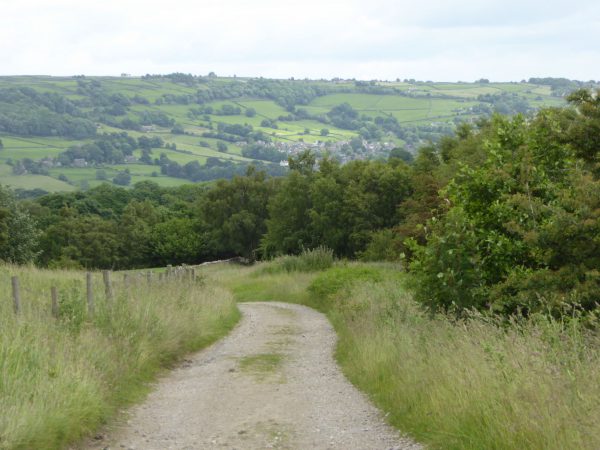
Leaving the caravan park the track starts to climb above Ashford Side Beck, we are now on a section of the Nidderdale Way. It is a stunning day and the views into the valley are cracking. What a great place to be!
We continue to follow the Nidderdale Way signs, which lead from the main track down towards the beck and then over a footbridge to enter a disused lead mine. This was known as Prosperous Mine.
I am absolutely fascinated by our industrial heritage and wandering into a site like this is amazing. You can still get a real feel of the size and structure of the mine, which is startling when you consider that it closed in the 1870’s and was totally abandoned in the 1890’s.
Mining is known to have started on this site in 1781 and continued for the best part of a hundred years, today the site is scheduled as a national monument. You need to be prepared to walk to get to it, but I promise you it is worth every step.
The path is not exactly clear because there are numerous routes where people have explored the site, however, if you are walking uphill you will soon come to the main track of the Nidderdale way. At a junction of paths we tack a bridleway sign to our right to follow another track, leaving the Nidderdale Way.
We are heading towards Greenhow and the path is clearly defined and soon leads to more disused mines. Subsequently I have looked at pictures of Cockhill Smelt Mill taken in the early 1900’s. It clearly shows this as a major industrial area.
Today there are a number of finger posts with interesting snippets of information that point out entrances to mines that could be easily overlooked by the untrained eye. We read that Cockhill Level was the main horse level and led into 8 to 9 miles of interconnected tunnels under Greenhow and Coldstone Hills. Driven in 1782 it was still accessible in the 1940’s. There are warnings that it is unsafe to enter; this had not even crossed my mind!
Another finger post points out the entrance to Jack Ass level cut into the Red Scar Grit. Apparently the pick marks in the gritstone at the entrance show clearly it was cut by hand, hard graft. The bit I find interesting is the shape of the entrance, narrow at the bottom at feet and leg level and wider at shoulder level, such was the desire to cut and carry out the minimum amount of material necessary.
You could easily spend hours looking about here, but we still have plenty of walking to do and the sky is beginning to cloud over.
At a fork in the path we take the left option and follow this route into Greenhow. At the road (B6265) we turn right and then quickly left to join Duck Street, which becomes Redlish Road. We walk besides the road for 2.5 miles; it is not busy just the occasional car or a lorry coming from Coldstones Quarry.
We leave the road turning left at a signed footpath leading to High House. Following the way markers we are soon on Braithwaite Moor, we turn left to follow a path (which is not always clear but runs besides a dry stone wall), to our right across the moor is Palleys Crags.
We soon join a track taking us across Fosse Gill, which then climbs up before levelling out. We are blasted by occasional heavy showers as we cross Flat Moor. There are a number of grouse butts and Lynnie tries to work out if they are evenly spaced by counting steps between them. I am encouraged to join in but then get accused of messing about by putting in the occasional long stride or a few short ones. I am told plainly that if I am not going to take this seriously then I cannot partake. Lynnie will keep the secret of her research to herself and I will have to spend the rest of my days pondering the findings. No doubt I will wake in the middle of the night worrying about this major issue.
The rain has become rather more persistent and the wind is making it unpleasant on this exposed moor. Thankfully the stony track is clear and not boggy. The scenery is cracking and makes up for the miserable weather.
As we approach a farm (Ravens Nest) we turn left and soon join a minor road by a disused quarry. This road goes steeply downhill. After a series of bends we leave the road to join a footpath on our right leading into woodland and across a footbridge as it heads towards Strikes Farm.
On reaching another minor road we turn left going downhill towards Turner Bridge where we turn left and then at the next junction keep straight on heading back towards Pateley Bridge.
It has been a wonderful walk covering almost ten and a half miles. A great opportunity to revisit another place not seen since my childhood and reminisce about old times. A bonus has been the fascinating industrial sites and wonderful scenery.
It is time to head back to West Lees Farm CL and start packing up. We will be leaving Yorkshire tomorrow for Salisbury; our extended tour will have kept us away from home for fifty-one nights. As yet we don’t have any firm plans for our next trip but rest assured it won’t be too long before the Coachman is hitched up and we are off exploring once more.
To view this 10 mile route on OS Maps Click Here
To follow this walk you will need Ordnance Survey Explorer Map 298 –Nidderdale
27th June 2016
© Two Dogs and an Awning (2016)