

Since arriving at Carr’s Hill CL I have seen the distant Ochil Hills everyday on my early morning walk. They look a cracking range of hills and Lynnie has already correctly predicted that we will be wandering on them. It is a fine, but cool day so perfect to wander up high.
The starting point for our jaunt is Tillicoultry and we park in Upper Mill Street . We head off up the road and on reaching a park we check the map. The local postman helpfully warns that some of the footpaths through the glen are closed because of falling rocks and points us right along a track and then within twenty or so yards turning left to climb steps to a metal gate. This is a steep climb and a foretaste of what is to come.
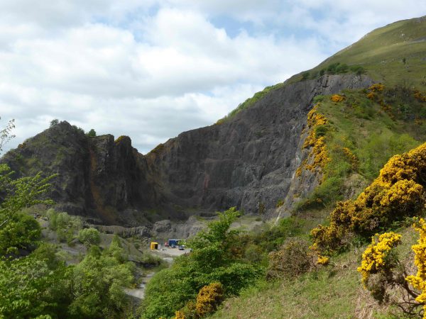
Through the gate we follow the path as it climbs between the gorse, on the opposite side of the Glen there is a large quarry. The OS map shows it as disused but there looks like there is still some activity there.
As the main path curves left to go around the edge of Mill Glen we take a fainter path on the right and continue on this as it zig zags its way to a metal bench where we meet a clearer path winding around the hillside. It is warm and pleasant so we stop to admire the view; behind us over the Forth Estuary and in front of us is the summit of The Law.
We pass a large boulder besides the path and continue on until the path divides near an old gate and gatepost. We go to the right and follow the line of an old fence, some of the metal fence posts have fallen across the path and become embedded in the ground. After passing a cairn we reach a fence and cross this and then follow the broad path to the summit of King’s Seat Hill. This is a fine hill 2,126 feet high offering stunning views in every direction.
Our route down is straight on and a quick descent, a bit of a test for my knee but it holds well even in these difficult conditions.
Heading downhill we reach a memorial to three Spitfires that crashed near the spot on 16th January 1943, they were operating from RAF Grangemouth. Two of the pilots lost their lives and one survived. It is a moving spot both the pilots who died were just 21 years old, such a tragic loss of life.
The path continues through a rocky section and then towards a fence where we go through a gate. We follow the main path along a ridge heading towards forestry land in the distance. As the path starts to descend we get wonderful views of Castle Campbell.
We bear slightly left and then climb a hill and go through a gate to a small hill with a seat on it. At the gate were signs warning of steep drops, so I am being very wary about the route. There are two options for entering Dollar Glen, we briefly explore the one to our left but I feel decidedly uncomfortable on the narrow path above steep drops into the Glen. We retrace our steps and take the route on the right, this has drops but nowhere near as bad and we walk through the Glen until we reach a path leading to Castle Campbell.
We have been admiring the Tower, built in 1430, whilst walking towards the Castle, so hope to take a look around. The staff are extremely helpful, but dogs are not permitted in the Castle (although they do produce biscuits for Dexter and Crosby and make a fuss of them).
After leaving the Castle we continue on down the Glen, significant work has been done to make this accessible with walkways around some of the steeper sections. It was a worthy project making this beautiful site accessible.
Eventually we emerge into a park with Dollar Golf Course on the opposite side of Dollar Burn the path brings us out by the small clubhouse. This is one of those courses that operates for much of the time with an honesty box. From what we have seen it looks an interesting little course, if we did not have the dogs with us I would be looking to have a knock around here.
Immediately on entering Dollar there is a feeling of prosperity, this is obviously a desirable spot to live. Perhaps it is the location of the Dollar Academy, a large independent school, that attracts people and prosperity here. I like the old water drinking fountain it has an inscription which says that it was erected with the surplus funds from an industrial exhibition held in Dollar in August 1890.
We follow the route of the Dollar Burn, crossing the main road and down the opposite side until we reach a path along a dismantled railway. Here there is a salmon ladder that was constructed at the end of last year.
Dollar is another of those places that has been devastated in the past by floods. Apparently on 28th August 1877 there had been heavy rainfall the previous day and overnight, this resulted in debris being washed down the fast flowing river. It is estimated that 2,650 tons of debris was removed from the river around the point where we are now standing.
Our route is now along the dismantled railway line back to Tillicoultry. This route has been recently resurfaced, frankly it is far better than most of the roads we experience back at home in the lanes of Wiltshire. We walk for about three miles along this tranquil and pleasant route with the River Devon to our left.
Back in Tillicoultry we pass the fine clock tower that has an inscription on it stating that the popular institute was erected in 1859 and the tower erected in 1878. The tower which is owned by Clackmannanshire Council is in a poor state of repair. Later internet research shows that there has been a campaign led by local people to prevent the tower from falling into such a state that it would need demolishing. What a great shame that such a fine building is at risk of being demolished because of neglect.
It has been a cracking walk, my Suunto Traverse shows that we have covered just over nine miles a good mix of hills with a flat section and plenty of interesting things to see along the way. I am sure that we will be returning to the Ochil Hills in the next few days, there are plenty more peaks to tackle.
25th May 2016
[To follow this walk you will need Ordnance Survey Explorer Map 366 – Stirling & Ochil Hills West]
© Two Dogs and an Awning (2016)