

After yesterday’s walk along parts of the Saints’ Way we are keen to explore another section of this long distance path. A quick look at the map and we have worked out a circular route starting from nearby Helman Tor.
The journey to Helman Tor involves some very narrow lanes, but thanks to some good navigation from Lynnie we arrive in the car park close to the Tor. I don’t know what I was expecting, but it certainly wasn’t this.
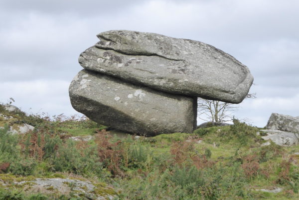
Our original plan had been to use the car park as a convenient starting point for our walk and bag the trig point on the way back. But Helman Tor is an amazing spot so we decide to explore before heading off for a walk.
This is the site of a prehistoric hill fort with a stone hut settlement. Apparently some of this dates to the Neolithic period, about 6,000 years ago. Such places are so evocative, it is a breezy afternoon and we are alone on the Tor so it is easy to imagine past inhabitants standing on this spot and looking out.
Dexter seems to be in reflective mood as he surveys the view, I think he has sussed this is a walk unlikely to yield ice cream and is trying to identify any alternative food source.
Whilst admiring the view we make sure to climb up to the trig point, this is the 35th OS trip point we have “bagged”. I regret not starting to record them earlier because we have visited many more but do not have photographic evidence to support our bagging. The upside is that we will have to revisit a number to add them to our total.
We could spend hours here, but we have walking to do, so make our descent from the summit in a westerly direction. On reaching the road we turn right and follow the lane to a junction and then turn left. The road leads through an area of wetland, apparently there are 500 acres of wetland around here. It was created by centuries of tin streaming. It is an amazing place to walk through; very interesting in the afternoon, but it would be spooky after dark, it has the feel of primeval swampland, one half expects an Alligator to emerge from the depths!
We are walking along a road but it is a very quiet country lane forming part of the Saints’ Way. Sections of the road are water covered from the wetlands. I would not want to be driving around here during a cold spell.
At a junction we carry straight on towards the hamlet of Lowertown, which is dominated, by a large chapel. The memorial plaque on the wall is to William O’Bryan who was “born at Gunwen Farm. February 6th 1778 gave the land and helped to build the first chapel on this site c1796 founded the Bible Christian Church at Week St Mary October 1st 1815, died at New York January 8th 1868.” Until a few days ago I had never heard of O’Bryan, but when walking near Great Torrington at Berry Cross I passed the chapel where he first preached. It is odd how our travel locations unintentionally link to each other, it is part of the enjoyment of getting out and about and learning more about the places we visit.
We walk through Lowertown and then at a junction continue straight on where the Saints’ Way turns to the right to head around Gunwen Farm. We carry on along the country lane ignoring the next turning on the right, but soon taking a right turn along a lane marked as National Cycle Way route 3. This takes us to Roseny Mill, which has a wonderful pigsty by the road where we turn the corner.
The road now takes us past the disused quarry at Luxulyan. The quarry provided a particular form of granite known as Luxulianite. The site is now an area of special scientific interest but there is no public access, at regular intervals along the fence there are signs warning of the hazardous nature of the quarry. In the village of Luxulyan we pass the church of St Julitta and her son St Cyriacus it was built in the late 1400s with the tower and porch added in the early 1500s. As you might expect it is built of the local granite.
I stay outside with the dogs whilst Lynnie pops in to have a look around. She is very taken with the Norman font, which predates the current church leading to suggestions there was an early church on the site.
Leaving the church we turn left and walk downhill to Gatty’s Bridge and then turn left to follow the lane, passing entrances to farms, there is no traffic and this is pleasant walking. After about a mile we pass a trig point that is across a field on the edge of woodland. There does not appear to be public access, but a scramble up the bank provides a good sighting of my 36th OS trig point.
Turning left at an old chapel we follow the lane, once again we are on the Saints’ Way. We leave the tarmac lane to follow the Saints’ Way route markers as it heads to the right to climb up to a ridge. The path is a broad track and easy to follow, however a few sections are particularly boggy and need careful detours onto banks to make them passable.
After about a mile and a half we are back at the base of Helman Tor. It is tempting to go up for another wander around, but it is dusk and we need to head back to Fowey CL so the dogs can have their well earned dinner.
To view this route on OS Maps Click Here
To follow our walk you will need Ordnance Survey Outdoor Explorer Map 127 – St Austell & Liskeard
4th October 2017
© Two Dogs and an Awning (2017)