

Last year whilst staying at Cadeside CAMC in Wellington we visited Dunkery Beacon and had a wonderful afternoon, I remember the spectacular views so I have decided to return there today. It is unusual for me to drive far to start a walk, but today it takes over an hour to get from Cadeside CAMC to the village of Horner where I park in the National Trust car park.
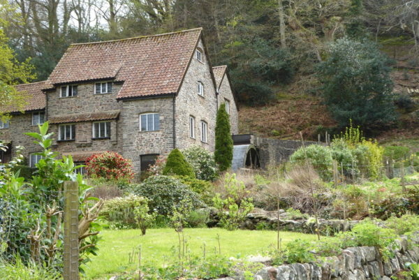
I leave the car park close to the tearooms and on reaching the lane turn left soon passing Horner Mill, built around 1839. In recent years it has been converted into a private dwelling. The Mill’s website tells how an ongoing dispute with the Environment Agency concerning the abstraction of water prevents water being diverted to the mill.
Soon after passing the mill I take a footpath on the right going uphill through Horner Plantation, this is a cracking bit of woodland to wander through just as the new leaves are beginning to appear.
On reaching a minor road I join it and walk uphill towards Webber’s Post, as the road forks I take the left option and very soon take a footpath on the left waymarked to Brockwell.
This route is shown on the map as the Dunster Path, thiswell-defined route is easy to follow, there are paths leading away to our left and fainter tracks to the right, but I continue on the main track. Across the valley Selworthy church stands out through the mizzle that has descended.
Just short of Brockwell I take a path on the right and follow this around the hill until I reach another well-defined path, the Macmillan Way West, this ascends Dunkery Hill. The weather is now utterly miserable. Lynnie and I walked this path just over a year ago; on that occasion it was misty and getting dark as we neared the end of a long walk. I had hoped that today I might get to appreciate some views, but there is no chance.
After crossing a minor road I continue on the broad track to the top of Dunkery Hill. I am walking into a prevailing south westerly-wind and as a soon as I am on the top I am buffeted by strong winds. The visibility is poor and in these conditions, it is not a spot to hang around.
Dunkery Beacon sits on top of Dunkery Hill which at 1,705 feet is the highest point in Exmoor and Somerset. As well as the beacon there is an OS trig point, it now becomes my forty-ninth bagged trig point.
Leaving the Beacon I continue west, straight into the wind and rain, after about a quarter of a mile I take a path on the right leading downhill across Goosemoor Common. Going downhill I am slightly protected from the wind but it is still unpleasant.
Coming to a track I turn left to follow it through Bagley Combe it then climbs to a minor road. I cross it to follow a path towards Stoke Pero, turning left at a minor road before heading steadily downhill to pass Stoke Pero church. This claims to be the highest altitude church in England.
Shortly after the church I take a footpath on the right, through a farmyard to join a track heading to Stoke Wood. Soon I enter a field of pasture and then go through a gate into Stoke Wood.
The steep path descends quickly as it traverses the side of the combe heading down to the confluence of the streams running down Prickslade Combe and Horner Water.
I cross Horner Water by a footbridge and turn right to follow a broad path through Horner Wood.
This is another stunning section of woodland and I appear to have it all to myself.
The route back to Horner is clearly marked, it is simply a case of keeping the stream to my right until I reach the old bridge crossing Horner Water.
From here I take the short walk back to the National Trust car park. I have covered close to ten miles, much of it in rough weather, but it has been a cracking ramble. The next time I walk up Dunkery Hill I plan to do it on a fine sunny day!
To view this 9 mile walk on OS Maps Click Here
To follow this walk you will need Ordnance Survey Outdoor Leisure Map 9 – Exmoor.
24th April 2018
© Two Dogs and an Awning (2018)
Another interesting route. I followed one that was initially similar two years ago, as far as Dunkery Beacon and my return was through Hawk Ridge. A really nice wooded combe with a stream and no-one else about. The downside was that it was uphill on the way back to Horner! 😉