

When looking at a map to plan a walk there are two things likely to grab my attention. The first is a big hill (as long as it does not have any precipitous drops), the other is a large lake or reservoir. In this part of the country there are not too many large hills but, as we discovered a few days ago, there is an attractive reservoir very close by!
We have heard conflicting tales about how far it is around Bewl Water, they range from twelve to eighteen miles so there is only one way to find out and that’s to walk it ourselves! We leave Waghorn’s CL and turn right along Newbury Lane at the junction we turn right again along Windmill Lane and head down into Cousley Wood to cross the road to Butts Lane beside the Vine pub. We continue along it to Little Butts Farm where we go through a kissing gate to take a permissive path through Bewl Water Woods to a path that goes around the reservoir.
We now have to make a decision, which way round should we go. I think that last time we walked around a reservoir, Loch Leven in Fife, we went anti-clockwise, so by way of a change, today we go clockwise.
The route is easy going and straightforward. The water level is particularly low at the moment, which initially allows us to leave the main path to walk along the water’s edge. Naturally a feature of walking around a reservoir is following the course of the inlets, this often means walking for ten minutes to reach a path you could see a couple of hundred yards away the other side of a span of water.
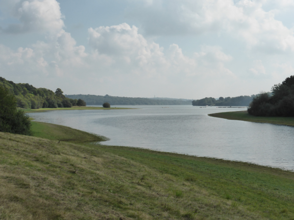
Apparently Bewl Water is the largest stretch of open water in South East England and a key source of drinking water for East Sussex and Kent. Work on the site started in 1973 and was completed in 1975. The reservoir holds 31 thousand million litres of water, which equates to an average day’s water usage for 200 million people.
I am surprised how high the average daily water usage per person is; 150 litres sounds like a lot of water! When we get back home I will be checking the water meter. The water barrel on the caravan holds 50 litres thankfully I don’t fill that up six times a day!
Our route soon enters a patch of woodland, one of the joys of walking around reservoirs is that you often get spells by the waters edge and then the contrast of woodland.
Briefly the route heads away from the water whilst it skirts around Hook Farm, but there is a footpath on the right that we take leading to slipways.
There are plenty of people here so we guess we must be close to the car park and café. A group of youngsters are on the water learning how to sail. One of the great things about expanses of water like this is the opportunity they give children to partake in activities that would not otherwise be available to them.
We have reached the dam, providing another perspective on looking out over the water. There are boats of fishermen and we stop briefly to try and spot something being landed. Later I read that this week an additional 1600 rainbow trout were stocked into the reservoir, the chaps we are watching are struggling to find them! This is said to be due to the warm weather pushing the trout into deeper water. According to the fishing returns only 48 trout were caught this week! I don’t understand fishing but that seems a very low number to me.
I do like the internet, you discover things that you never thought you needed to know, for example the fishing return for the week states the reservoir was 71% full and the water temperature was 21c. Had we known that we could have hopped in for a bath (it would have saved me carrying more water for the caravan shower), but of course you are not allowed to swim in a reservoir.
On crossing the dam we meet a couple of dumper trucks coming from the opposite direction and a bit further on there is machinery laying a hardcore path for walkers and cyclists. Making places like this more accessible for those with mobility issues, or with young children in buggies is to be applauded. We have passed a few elderly people out for a stroll; it has to be better for folks’ well-being to be out in the country rather than cooped up in front of a TV watching “Escape to the Country”.
We contemplate stopping on a bench for a sandwich, but agree on walking to the far side of the reservoir; we estimate this should take about 30 minutes and it will enable us to sit in the autumnal sunshine. We spot just the right location across the water.
We briefly join a minor road and then on returning to the reservoir path we are on the right side for a picnic and there are plenty of benches. The first are in shade so we carry on, midges surround the next lot. Then we get to the spot we had spied earlier from across the water, but someone else has got there ahead of us! Undeterred we continue on, hungrily, there have been so many benches we are bound to come to another one soon.
I do not usually advocate putting signs up in the countryside or places of beauty, but I do feel there is merit in a signage policy around reservoirs similar to that used on motorways. When driving you are told how far it is to the next service station so you can make an informed decision. Had we known the distance to the next bench we would have gone back a few hundred yards, because we walk for over an hour before the next one!
Before reaching the bench we have a spell where the path leaves the water’s edge following minor lanes for a couple of miles. It is not without interest and we only meet two cars along the way, however, after the beauty of walking besides the reservoir it is a little disappointing.
However, on returning to the waters edge we do have a bench to sit on and a stunning view (but still have plenty of flies buzzing around).
Resuming our walk we soon arrive at the point where a few days ago we left the reservoir to walk back to Cousley Wood on the Sussex Border path. We contemplate taking this route, however, the pedant in me says we cannot claim to have walked around the reservoir if we do not reach the point from which we started. So we continue to Bewl Water Wood and retrace our steps back from Little Butts Farm to the site.
Starting and finishing at Waghorn’s CL our walk has covered about thirteen and a half miles, from this I calculate the route around the reservoir to be somewhere in the region of eleven and a half miles.
In the evening we wander down to the Old Vine for an excellent meal, it is as good as the reviews. The only downside is that I discover that I don’t particularly like the taste of Harvey’s bitter. The locals are drinking it, so I know it is my taste buds rather than the quality of the ale. This time last year I was enthusiastically sampling Pendle Witch in the Talbot in Settle, but there are few beers or pubs that can compare to that! Cheers!
To view this 13.5 walk on OS Maps Click Here
To follow our walk you will need Ordnance Survey Explorer Map 136 – High Weld
21st September 2016
© Two Dogs and an Awning (2016)
Hi. Thanks for the description of the walk around Bewl water. I walked the route from the main centre and back to the start (anti-clockwise as it happens), taking the route away from the reservoir on country lanes as per the walk signage, and my GPS tracker clocked 13.2 miles.